
Advertisement
-
Published Date
June 17, 2025This ad was originally published on this date and may contain an offer that is no longer valid. To learn more about this business and its most recent offers, click here.
Ad Text
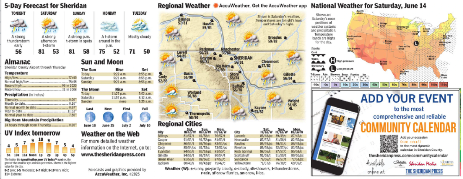
5-Day Forecast for Sheridan TONIGHT SATURDAY SUNDAY MONDAY TUESDAY A strong thunderstorm A strong afternoon t-storm early 56 81 53 A strong p.m. At-storm Mostly cloudy t-storm in spots around in the p.m. Almanac Sheridan County Airport through Thursday 81 58 75 52 71 50 Sun and Moon Parkman Ranchester Lovell 56/79 Regional Weather AccuWeather. Get the AccuWeather app National Weather for Saturday, June 14 Billings 57/81 Hardin 59/84 Shown is Saturday's weather. Temperatures are tonight's lows and Saturday's highs. Broadus 59/82 Shown are Saturday's noon positions of weather systems and precipitation. Temperature bands are highs for the day. Fronts Cold 30 179 54/85 Dayton SHERIDAN 55/81 56/81 Big Horna Clearmont 57/82 The Sun Rise Temperature High/low...... Normal high/low Record high Record low.... Today 5:22 a.m. Set 8:55pm. 56/89 HHigh pressure BPse Stationary Low pressure Basin Story 77/49 Saturday 5:21 a.m. 8:55 pm. Cody 56/90 55/74 Gillette 56/84 To Rain Showers Snow Pantes 75/46 Sunday 5:21 am. 8:56 pm. 52/85 ....95 in 2020 -10s Os 10s 20s 30s 50s 60s 70s 80s 90s 100s 110s 31 in 2008 The Moon Rise Set Buffalo 55/78 Precipitation (in inches) Today 11:27 p.m. 7:02am. Saturday 11:57 p.m. 8:12 am. Worland 56/88 Thursday... Month to date... Normal month to date.. Year to date -0.00 0.10" 0.97 Sunday none 9:25 am. Last New First Full 11.52" Wright 56/85 Kaycee 53/82 7.80 June 18 June 25 July 2 Weather on the Web July 10 Regional Cities City Billings 7 For more detailed weather 5 Casper Cheyenne Normal year to date. Big Horn Mountain Precipitation 24 hours through noon Thursday..............0.00 UV Index tomorrow 9 10 9 Sa 10a 11a Noon 1p 2p 3p 4p 5p The higher the AccuWeather.com UV Index number, the greater the need for eye and skin protection. Shown is the highest value for the day 0-2 Low: 3-5 Moderate; 6-7 High: 8-10 Very High: 11+ Extreme Mon Hi/Lo/W Hi/Lo/W Hi/Lo/W 81/57/1 81/58/1 76/57/1 91/53/1 91/52/pc 81/53/t 86/54/1 86/56/pc 83/53/pc 85/54/pc 81/53/C 73/52/pc Evanston 84/55/s 83/53/pc 81/50/c Gillette 84/56/1 86/57/ 80/54/t Green River 91/56/s 89/56/c 87/53/c Jackson information on the Internet, go to: Cady Www.thesheridanpress.com Forecasts and graphics provided by AccuWeather, Inc. <2025 80/40/5 80/42/pc 75/42/c Newcastle Rawlins Riverton Rock Springs Scottsbluff Sundance Yellowstone 87/57/1 81/58/1 82/55/pc 89/49/pc 90/51/ 86/49/pc 89/58/pc 92/57/pc 83/52/pc 88/56/5 87/57/ 85/53/s 92/58/1 91/59/1 89/56/pc 76/56/ 76/57/ 71/37/5 76/38/C 72/52/pe 69/39/ online at Weather (W): s-sunny, pc-partly cloudy, c-cloudy, sh-showers, t-thunderstorms, r-rain, sf-snow flurries, sn-snow, i-ice. Thermopolis 58/90 City Laramie Sat. Sun, Mon. Hi/Lo/W Hi/Lo/W Hi/Lo/W 86/48/pc 89/49/ 87/47/ endar 28 ADD YOUR EVENT to the most comprehensive and reliable COMMUNITY CALEND Add your occasion (FOR FREE!) to the most dynamic calendar in Sheridan County. thesheridanpress.com/communitycalendar Available Sheridan Media THE SHERIDAN PRESS 5 - Day Forecast for Sheridan TONIGHT SATURDAY SUNDAY MONDAY TUESDAY A strong thunderstorm A strong afternoon t - storm early 56 81 53 A strong p.m. At - storm Mostly cloudy t - storm in spots around in the p.m. Almanac Sheridan County Airport through Thursday 81 58 75 52 71 50 Sun and Moon Parkman Ranchester Lovell 56/79 Regional Weather AccuWeather . Get the AccuWeather app National Weather for Saturday , June 14 Billings 57/81 Hardin 59/84 Shown is Saturday's weather . Temperatures are tonight's lows and Saturday's highs . Broadus 59/82 Shown are Saturday's noon positions of weather systems and precipitation . Temperature bands are highs for the day . Fronts Cold 30 179 54/85 Dayton SHERIDAN 55/81 56/81 Big Horna Clearmont 57/82 The Sun Rise Temperature High / low ...... Normal high / low Record high Record low .... Today 5:22 a.m. Set 8:55 pm . 56/89 HHigh pressure BPse Stationary Low pressure Basin Story 77/49 Saturday 5:21 a.m. 8:55 pm . Cody 56/90 55/74 Gillette 56/84 To Rain Showers Snow Pantes 75/46 Sunday 5:21 am . 8:56 pm . 52/85 .... 95 in 2020 -10s Os 10s 20s 30s 50s 60s 70s 80s 90s 100s 110s 31 in 2008 The Moon Rise Set Buffalo 55/78 Precipitation ( in inches ) Today 11:27 p.m. 7:02 am . Saturday 11:57 p.m. 8:12 am . Worland 56/88 Thursday ... Month to date ... Normal month to date .. Year to date -0.00 0.10 " 0.97 Sunday none 9:25 am . Last New First Full 11.52 " Wright 56/85 Kaycee 53/82 7.80 June 18 June 25 July 2 Weather on the Web July 10 Regional Cities City Billings 7 For more detailed weather 5 Casper Cheyenne Normal year to date . Big Horn Mountain Precipitation 24 hours through noon Thursday .............. 0.00 UV Index tomorrow 9 10 9 Sa 10a 11a Noon 1p 2p 3p 4p 5p The higher the AccuWeather.com UV Index number , the greater the need for eye and skin protection . Shown is the highest value for the day 0-2 Low : 3-5 Moderate ; 6-7 High : 8-10 Very High : 11+ Extreme Mon Hi / Lo / W Hi / Lo / W Hi / Lo / W 81/57/1 81/58/1 76/57/1 91/53/1 91 / 52 / pc 81 / 53 / t 86/54/1 86 / 56 / pc 83 / 53 / pc 85 / 54 / pc 81 / 53 / C 73 / 52 / pc Evanston 84 / 55 / s 83 / 53 / pc 81 / 50 / c Gillette 84/56/1 86 / 57 / 80 / 54 / t Green River 91 / 56 / s 89 / 56 / c 87 / 53 / c Jackson information on the Internet , go to : Cady Www.thesheridanpress.com Forecasts and graphics provided by AccuWeather , Inc. < 2025 80/40/5 80 / 42 / pc 75 / 42 / c Newcastle Rawlins Riverton Rock Springs Scottsbluff Sundance Yellowstone 87/57/1 81/58/1 82 / 55 / pc 89 / 49 / pc 90 / 51 / 86 / 49 / pc 89 / 58 / pc 92 / 57 / pc 83 / 52 / pc 88/56/5 87 / 57 / 85 / 53 / s 92/58/1 91/59/1 89 / 56 / pc 76 / 56 / 76 / 57 / 71/37/5 76 / 38 / C 72 / 52 / pe 69 / 39 / online at Weather ( W ) : s - sunny , pc - partly cloudy , c - cloudy , sh - showers , t - thunderstorms , r - rain , sf - snow flurries , sn - snow , i - ice . Thermopolis 58/90 City Laramie Sat. Sun , Mon. Hi / Lo / W Hi / Lo / W Hi / Lo / W 86 / 48 / pc 89 / 49 / 87 / 47 / endar 28 ADD YOUR EVENT to the most comprehensive and reliable COMMUNITY CALEND Add your occasion ( FOR FREE ! ) to the most dynamic calendar in Sheridan County . thesheridanpress.com/communitycalendar Available Sheridan Media THE SHERIDAN PRESS