
Advertisement
-
Published Date
June 5, 2025This ad was originally published on this date and may contain an offer that is no longer valid. To learn more about this business and its most recent offers, click here.
Ad Text
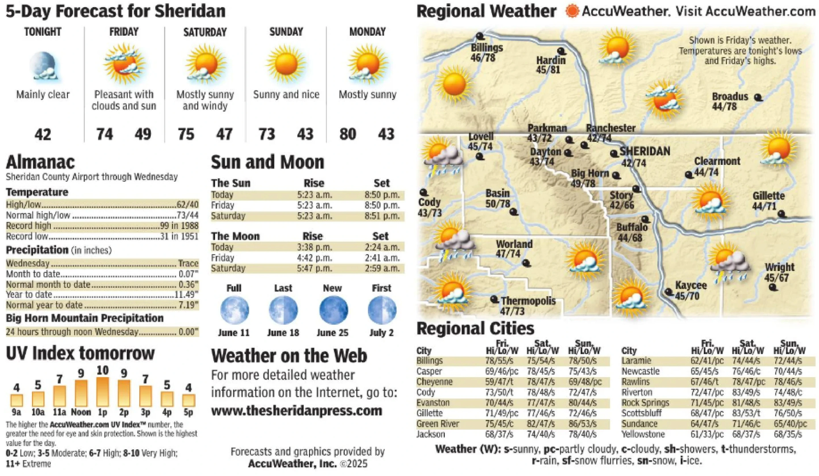
5-Day Forecast for Sheridan TONIGHT FRIDAY SATURDAY SUNDAY MONDAY Regional Weather AccuWeather. Visit AccuWeather.com Billings 46/78 Hardin 45/81 Shown is Friday's weather. Temperatures are tonight's lows and Friday's highs. Mainly clear Pleasant with clouds and sun Mostly sunny Sunny and nice and windy Mostly sunny Broadus 44/78 Parkman 42 74 49 75 47 73 43 80 43 Lovell 43/72 Ranchester 42/74 45/74 Dayton Almanac Sun and Moon 43/74 SHERIDAN 42/74 Clearmont Big Horn 44/74 Sheridan County Airport through Wednesday The Sun Rise Set 49/78 Temperature Today 5:23 a.m. 8:50 p.m. Basin High/low........... 62/40 Friday 5:23 a.m. 8:50 p.m. Cody 50/78 Story 42/66 Gillette 44/71 Normal high/low...... ......73/44 Saturday 5:23 a.m. 8:51 p.m. 43/73 Record high .99 in 1988 Record low... .31 in 1951 The Moon Rise Set Buffalo 44/68 Precipitation (in inches) Today 3:38 p.m. 2:24 a.m. Worland 47/74 Friday 4:42 p.m. 2:41 a.m. Wednesday........ Trace Saturday 5:47 p.m. 2:59 a.m. Month to date..... 0.07" Normal month to date........ 0.36" Full Last New First Year to date. 11.49" Normal year to date.... 7.19" Thermopolis 47/73 Wright 45/67 Kaycee 45/70 Big Horn Mountain Precipitation 24 hours through noon Wednesday................. 0.00" UV Index tomorrow 7 9 10 9 7 4 5 4 Weather on the Web For more detailed weather information on the Internet, go to: 9a 10a 11a Noon 1p 2p 3p 4p 5p Www.thesheridanpress.com The higher the AccuWeather.com UV Index number, the greater the need for eye and skin protection. Shown is the highest value for the day. 0-2 Low; 3-5 Moderate; 6-7 High; 8-10 Very High; 11+ Extreme June 11 June 18 June 25 July 2 Regional Cities City Billings Casper Cheyenne Cody Evanston Gillette Green River Jackson Fri. Sat. Sun Hi/Lo/W Hi/Lo/W Hi/Lo/W 78/55/s 75/54/s 78/50/s 69/46/pc 78/45/5 75/43/s 59/47/t 78/47/5 69/48/pc 73/50/t 78/48/s 72/47/s 70/44/s 77/47/s 80/44/s 71/49/pc 77/46/s 72/46/s 75/45/c 82/47/5 86/53/s 68/37/s 74/40/s 78/40/s Sat City Laramie Newcastle Rawlins Riverton Rock Springs Scottsbluff Sundance Yellowstone Fri. Hi/Lo/W Hi/Lo/W Hi/Lo/W 62/41/pc 74/44/5 72/44/s 65/45/s 76/46/c 70/44/s 67/46/t 78/47/pc 78/46/s 72/47/pc 83/49/s 74/48/c 71/45/pc 81/48/s 83/49/s 68/47/pc 83/53/t 76/50/s 64/47/s 71/46/C 65/40/pc 61/33/pc 68/37/s 68/35/s Sun Forecasts and graphics provided by AccuWeather, Inc. ©2025 Weather (W): s-sunny, pc-partly cloudy, c-cloudy, sh-showers, t-thunderstorms, r-rain, sf-snow flurries, sn-snow, i-ice. 5 - Day Forecast for Sheridan TONIGHT FRIDAY SATURDAY SUNDAY MONDAY Regional Weather AccuWeather . Visit AccuWeather.com Billings 46/78 Hardin 45/81 Shown is Friday's weather . Temperatures are tonight's lows and Friday's highs . Mainly clear Pleasant with clouds and sun Mostly sunny Sunny and nice and windy Mostly sunny Broadus 44/78 Parkman 42 74 49 75 47 73 43 80 43 Lovell 43/72 Ranchester 42/74 45/74 Dayton Almanac Sun and Moon 43/74 SHERIDAN 42/74 Clearmont Big Horn 44/74 Sheridan County Airport through Wednesday The Sun Rise Set 49/78 Temperature Today 5:23 a.m. 8:50 p.m. Basin High / low ........... 62/40 Friday 5:23 a.m. 8:50 p.m. Cody 50/78 Story 42/66 Gillette 44/71 Normal high / low ...... ...... 73/44 Saturday 5:23 a.m. 8:51 p.m. 43/73 Record high .99 in 1988 Record low ... .31 in 1951 The Moon Rise Set Buffalo 44/68 Precipitation ( in inches ) Today 3:38 p.m. 2:24 a.m. Worland 47/74 Friday 4:42 p.m. 2:41 a.m. Wednesday ........ Trace Saturday 5:47 p.m. 2:59 a.m. Month to date ..... 0.07 " Normal month to date ........ 0.36 " Full Last New First Year to date . 11.49 " Normal year to date .... 7.19 " Thermopolis 47/73 Wright 45/67 Kaycee 45/70 Big Horn Mountain Precipitation 24 hours through noon Wednesday ................. 0.00 " UV Index tomorrow 7 9 10 9 7 4 5 4 Weather on the Web For more detailed weather information on the Internet , go to : 9a 10a 11a Noon 1p 2p 3p 4p 5p Www.thesheridanpress.com The higher the AccuWeather.com UV Index number , the greater the need for eye and skin protection . Shown is the highest value for the day . 0-2 Low ; 3-5 Moderate ; 6-7 High ; 8-10 Very High ; 11+ Extreme June 11 June 18 June 25 July 2 Regional Cities City Billings Casper Cheyenne Cody Evanston Gillette Green River Jackson Fri. Sat. Sun Hi / Lo / W Hi / Lo / W Hi / Lo / W 78 / 55 / s 75 / 54 / s 78 / 50 / s 69 / 46 / pc 78/45/5 75 / 43 / s 59 / 47 / t 78/47/5 69 / 48 / pc 73 / 50 / t 78 / 48 / s 72 / 47 / s 70 / 44 / s 77 / 47 / s 80 / 44 / s 71 / 49 / pc 77 / 46 / s 72 / 46 / s 75 / 45 / c 82/47/5 86 / 53 / s 68 / 37 / s 74 / 40 / s 78 / 40 / s Sat City Laramie Newcastle Rawlins Riverton Rock Springs Scottsbluff Sundance Yellowstone Fri. Hi / Lo / W Hi / Lo / W Hi / Lo / W 62 / 41 / pc 74/44/5 72 / 44 / s 65 / 45 / s 76 / 46 / c 70 / 44 / s 67 / 46 / t 78 / 47 / pc 78 / 46 / s 72 / 47 / pc 83 / 49 / s 74 / 48 / c 71 / 45 / pc 81 / 48 / s 83 / 49 / s 68 / 47 / pc 83 / 53 / t 76 / 50 / s 64 / 47 / s 71 / 46 / C 65 / 40 / pc 61 / 33 / pc 68 / 37 / s 68 / 35 / s Sun Forecasts and graphics provided by AccuWeather , Inc. © 2025 Weather ( W ) : s - sunny , pc - partly cloudy , c - cloudy , sh - showers , t - thunderstorms , r - rain , sf - snow flurries , sn - snow , i - ice .