
Advertisement
-
Published Date
July 29, 2025This ad was originally published on this date and may contain an offer that is no longer valid. To learn more about this business and its most recent offers, click here.
Ad Text
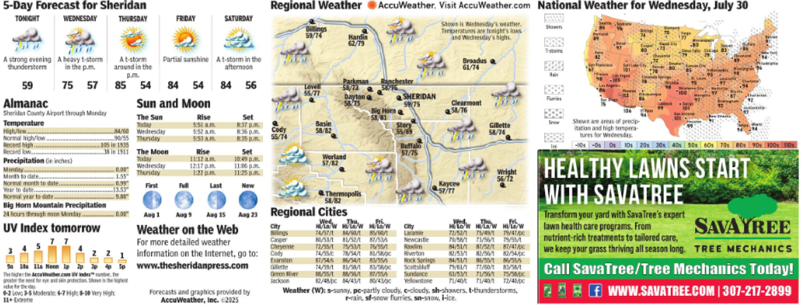
5-Day Forecast for Sheridan TONIGHT WEDNESDAY THURSDAY FRIDAY SATURDAY Regional Weather AccuWeather. Visit AccuWeather.com National Weather for Wednesday, July 30 Billings 59/74 Hardin 62/79 A strong evening A heavy t-storm thunderstorm A t-storm Partial sunshine A t-storm in the in the p.m. around in the p.m. afternoon Shown is Wednesday's weather. Temperatures are tonight's lows and Wednesday's highs. Showers T-storms Broadus 61/74 Rady 83 72 101 59 75 57 85 54 84 54 84 56 Lovell 55/77 Parkman Ranchester 58/73 Wate 100 Dayton Almanac Temperature High/law Sun and Moon 58 75 SHERIDAN 59/75 - Flurries UV Index tomorrow 7 7 2 2 1 4p Sa 10a 11a Noon 1p 2p 3p 4p The higher the AccuWeather.com UV Index number, the greater the need for eye and skin protection Shove is the highest ale for the day. 0-2 Low: 3-5 Moderate: 6-7 High: 8-10 Very High: 11+ Extreme Aug 1 Aug 9 Aug 15 Aug 23 Regional Cities Weather on the Web For more detailed weather information on the Internet, go to: www.thesheridanpress.com Forecasts and graphics provided by AccuWeather, Inc. ©2025 City Billings Cady Evanston Gillette Sheridan County Airport through Monday The Sun Today Rise Set 5:51a.m. 8:37 pm. Basin 84/60 Wednesday 5:52 a.m. 8:36 pm. Cody 58/82 Normal high/low. 90/55 Thursday 5:53 a.m. 8:35 pm. 55/74 Record high... 105 in 1935 Record low 38 in 1911 Precipitation (in inches) The Moon Today Rise Set 11:12 a.m. 10:49 pm. Monday 0.00 Month to date. Wednesday 1.55 Thursday 12:17 p.m. 11:06 pm. Worland 57/82 1:22 p.m. 11:25 pm. Normal month to date. Year to date. Normal year to date. 0.99 13.53" 9.80 First Full Last New Thermopolis 58/82 Big Horn Mountain Precipitation 24 hours through noon Monday... -0.00" Big Horn Clearmont 58/76 106 94 58/81 Story 55/69 Gillette 58/74 Snow Shown are areas of precip itation and high tempera- tures for Wednesday. Buffalo 57/75 Casper Cheyenne Wed, Thu, H/W HOW HI/LO/W 74/57/1 84/60/1 85/60/1 80/53/1 81/52/1 87/53/5 72/55/1 75/53/1 76/55/1 74/55/C 78/54/1 City Laramie Newcastle Rawlins 87/54/5 86/54/1 81/58/pc 83/55/5 Riverton Rock Springs 74/59/1 81/55/1 83/58/pc Scottsbluff Green River Jackson 88/55/1 88/55/1 87/55/5 Sundance 82/48/pc 84/43/1 80/43/pc Yellowstone Wright 56/72 Kaycee 57/77 Wed Fri H/LOW HI/LOW HILD/W 72/52/1 75/49/1 19/47/pc 70/58/1 73/56/1 79/35/t 84/51/1 87/52/1 87/47/ 82/53/1 82/56/1 82/54/DC 84/51/1 85/55/1 86/55/5 75/61/1 77/50/1 83/58/t 63/53/1 71/56/1 75/58/DC 71/40/ 71/40/1 12/40/DC Weather (W): 5-sunny, pc-partly cloudy, c-cloudy, sh-showers, t-thunderstorms, r-rain, sf-snow flurries, sn-snow, i-ice. -10s -Os Os 10s 20s 30s 40s 50s 60s 70s 80s 90s 100s 110s HEALTHY LAWNS START WITH SAVATREE Transform your yard with SavaTree's expert lawn health care programs. From nutrient-rich treatments to tailored care, SAVAYREE we keep your grass thriving all season long. TREE MECHANICS Call SavaTree/Tree Mechanics Today! 2f WWW.SAVATREE.COM | 307-217-2899 5 - Day Forecast for Sheridan TONIGHT WEDNESDAY THURSDAY FRIDAY SATURDAY Regional Weather AccuWeather . Visit AccuWeather.com National Weather for Wednesday , July 30 Billings 59/74 Hardin 62/79 A strong evening A heavy t - storm thunderstorm A t - storm Partial sunshine A t - storm in the in the p.m. around in the p.m. afternoon Shown is Wednesday's weather . Temperatures are tonight's lows and Wednesday's highs . Showers T - storms Broadus 61/74 Rady 83 72 101 59 75 57 85 54 84 54 84 56 Lovell 55/77 Parkman Ranchester 58/73 Wate 100 Dayton Almanac Temperature High / law Sun and Moon 58 75 SHERIDAN 59/75 - Flurries UV Index tomorrow 7 7 2 2 1 4p Sa 10a 11a Noon 1p 2p 3p 4p The higher the AccuWeather.com UV Index number , the greater the need for eye and skin protection Shove is the highest ale for the day . 0-2 Low : 3-5 Moderate : 6-7 High : 8-10 Very High : 11+ Extreme Aug 1 Aug 9 Aug 15 Aug 23 Regional Cities Weather on the Web For more detailed weather information on the Internet , go to : www.thesheridanpress.com Forecasts and graphics provided by AccuWeather , Inc. © 2025 City Billings Cady Evanston Gillette Sheridan County Airport through Monday The Sun Today Rise Set 5:51 a.m . 8:37 pm . Basin 84/60 Wednesday 5:52 a.m. 8:36 pm . Cody 58/82 Normal high / low . 90/55 Thursday 5:53 a.m. 8:35 pm . 55/74 Record high ... 105 in 1935 Record low 38 in 1911 Precipitation ( in inches ) The Moon Today Rise Set 11:12 a.m. 10:49 pm . Monday 0.00 Month to date . Wednesday 1.55 Thursday 12:17 p.m. 11:06 pm . Worland 57/82 1:22 p.m. 11:25 pm . Normal month to date . Year to date . Normal year to date . 0.99 13.53 " 9.80 First Full Last New Thermopolis 58/82 Big Horn Mountain Precipitation 24 hours through noon Monday ... -0.00 " Big Horn Clearmont 58/76 106 94 58/81 Story 55/69 Gillette 58/74 Snow Shown are areas of precip itation and high tempera- tures for Wednesday . Buffalo 57/75 Casper Cheyenne Wed , Thu , H / W HOW HI / LO / W 74/57/1 84/60/1 85/60/1 80/53/1 81/52/1 87/53/5 72/55/1 75/53/1 76/55/1 74 / 55 / C 78/54/1 City Laramie Newcastle Rawlins 87/54/5 86/54/1 81 / 58 / pc 83/55/5 Riverton Rock Springs 74/59/1 81/55/1 83 / 58 / pc Scottsbluff Green River Jackson 88/55/1 88/55/1 87/55/5 Sundance 82 / 48 / pc 84/43/1 80 / 43 / pc Yellowstone Wright 56/72 Kaycee 57/77 Wed Fri H / LOW HI / LOW HILD / W 72/52/1 75/49/1 19 / 47 / pc 70/58/1 73/56/1 79 / 35 / t 84/51/1 87/52/1 87 / 47 / 82/53/1 82/56/1 82 / 54 / DC 84/51/1 85/55/1 86/55/5 75/61/1 77/50/1 83 / 58 / t 63/53/1 71/56/1 75 / 58 / DC 71 / 40 / 71/40/1 12 / 40 / DC Weather ( W ) : 5 - sunny , pc - partly cloudy , c - cloudy , sh - showers , t - thunderstorms , r - rain , sf - snow flurries , sn - snow , i - ice . -10s -Os Os 10s 20s 30s 40s 50s 60s 70s 80s 90s 100s 110s HEALTHY LAWNS START WITH SAVATREE Transform your yard with SavaTree's expert lawn health care programs . From nutrient - rich treatments to tailored care , SAVAYREE we keep your grass thriving all season long . TREE MECHANICS Call SavaTree / Tree Mechanics Today ! 2f WWW.SAVATREE.COM | 307-217-2899