
Advertisement
-
Published Date
July 28, 2025This ad was originally published on this date and may contain an offer that is no longer valid. To learn more about this business and its most recent offers, click here.
Ad Text
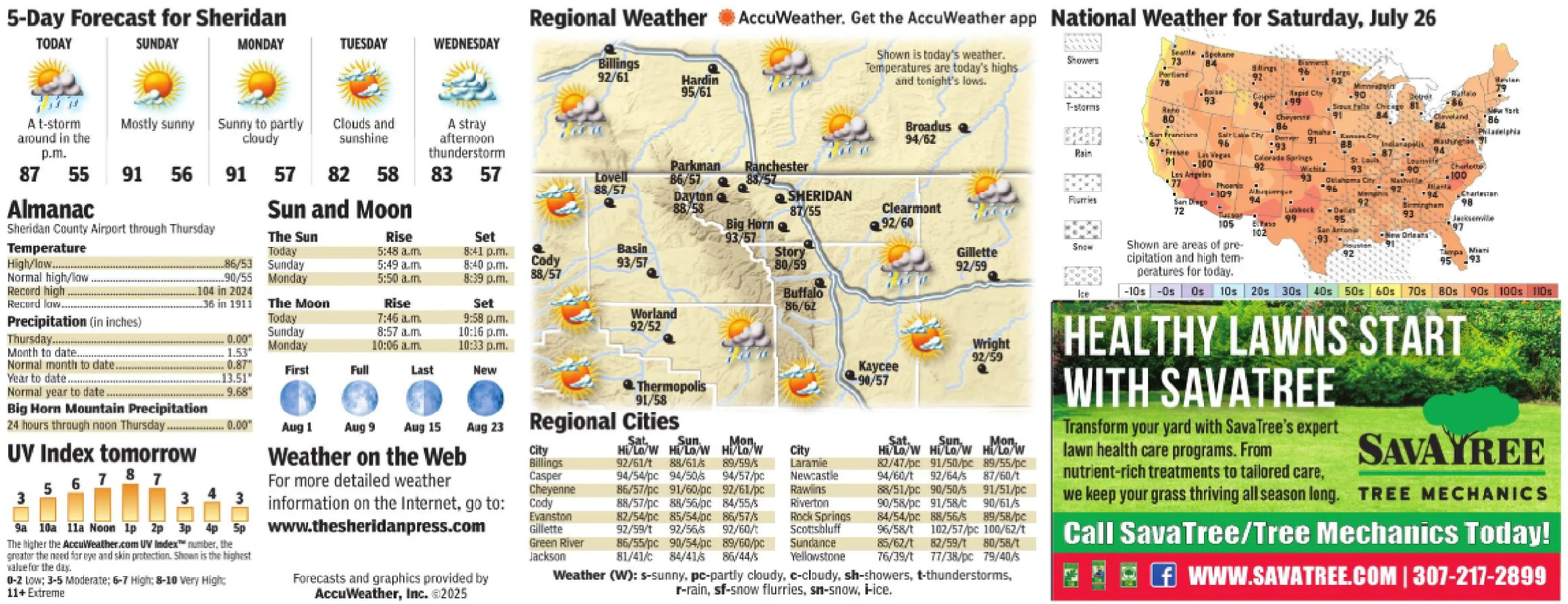
5-Day Forecast for Sheridan TODAY SUNDAY MONDAY TUESDAY WEDNESDAY Regional Weather AccuWeather. Get the AccuWeather app National Weather for Saturday, July 26 Billings 92/61 Hardin 95/61 Shown is today's weather. Temperatures are today's highs jokane Showers 73 Portland Billings and tonight's lows. Fargo 93 Boise 93 T-storms Cape 94 Rapid City .99 90 Sioux Falls Chicago 81 84 80 Broadus 94/62 Cheyenne 86 Rain San Francisco Frese Las Vegas 91 -100 Salt Lake City D 96 91 Omaha 93 Colorado Springs 92 Kansas City 88 Indianapolis athugan 87 94 Los Angeles 77 Wichita 93 90 Charlotte 100 Oklahoma City Phoenix -109 Furries Albuquerque 94 96 Memphis 92 +94 92 Charlestan 98 72 Lubbeck Tussar 105 Birmingham 93 102 95. San Antonio 93. 97 New Orleats Gillette 92/59 Snow Shown are areas of pre- cipitation and high tem- Houston 92 95 Tampa Miari 93 peratures for today. A t-storm around in the p.m. Mostly sunny Sunny to partly cloudy Clouds and sunshine A stray afternoon thunderstorm 87 55 91 56 91 57 82 58 83 57 Lovell Parkman 86/57 Ranchester 88/57 88/57 Dayton SHERIDAN Almanac Sun and Moon 88/58 87/55 Sheridan County Airport through Thursday Big Horn Clearmont 92/60 The Sun Rise Set 93/57 Temperature Today 5:48 a.m. 8:41 p.m. Basin Story High/low......... 86/53 Normal high/low. Sunday 90/55 Monday 5:49 a.m. 8:40 p.m. Cody 93/57 80/59 5:50a.m. 8:39 p.m. 88/57 Record high. ..104 in 2024 Record low.... 36 in 1911 The Moon Rise Set Buffalo 86/62 Precipitation (in inches) Today 7:46 am. 9:58 p.m. Worland 92/52 Sunday 8:57 a.m. 10:16 p.m. Thursday....... 0.00 Month to date.. 1.53" Monday 10:06 am. 10:33 p.m. Normal month to date.. 0.87 First Full Last New Year to date. 13.51 Normal year to date. 9.68" Thermopolis 91/58 Wright 92/59 Kaycee 90/57 Big Horn Mountain Precipitation 24 hours through noon Thursday. -0.00" City Billings Casper Cheyenne Evanston Gillette Green River Jackson Sat Sun Mon, Hi/Lo/W Hi/Lo/W Hi/Lo/W 92/61/t 88/61/s 89/59/s 94/54/pc 94/50/s 94/57/pc 86/57/pc 91/60/pc 92/61/pc 88/57/pc 88/56/pc 84/55/5 82/54/pc 85/54/pc 86/57/s 92/59/t 92/56/s 92/60/t 86/55/pc 90/54/pc 89/60/pc 81/41/c 84/41/s 86/44/s City Laramie Newcastle Rawlins Riverton Rock Springs Scottsbluff Sundance Yellowstone Sat. Sun Mon Hi/Lo/W Hi/Lo/W Hi/Lo/W 82/47/pc 91/50/pc 89/55/pc 94/60/t 92/64/s 87/60/t 88/51/pc 90/50/5 91/51/pc 90/58/pc 91/58/c 90/61/s 84/54/pc 88/56/5 89/58/pc 96/58/t 102/57/pc 100/62/t 85/62/1 82/59/t 80/58/t 76/39/1 77/38/pc 79/40/5 Weather (W): s-sunny, pc-partly cloudy, c-cloudy, sh-showers, t-thunderstorms, r-rain, sf-snow flurries, sn-snow, i-ice. -10s -Os Os 10s 20s 30s 40s 50s 60s 70s 80s 90s 100s 110s HEALTHY LAWNS START WITH SAVATREE Transform your yard with SavaTree's expert lawn health care programs. From nutrient-rich treatments to tailored care, SAVAYREE we keep your grass thriving all season long. TREE MECHANICS Call SavaTree/Tree Mechanics Today! f WWW.SAVATREE.COM | 307-217-2899 UV Index tomorrow 56787 3 Aug 1 Aug 9 Aug 15 Aug 23 Regional Cities Weather on the Web For more detailed weather 3 3 9a 10a 11a Noon Ip 2p 3p 4p 5p The higher the AccuWeather.com UV Index number, the greater the need for eye and skin protection. Shown is the highest value for the day. 0-2 Low: 3-5 Moderate; 6-7 High: 8-10 Very High: 11+ Extreme information on the Internet, go to: Cody Www.thesheridanpress.com Forecasts and graphics provided by AccuWeather, Inc. @2025 5 - Day Forecast for Sheridan TODAY SUNDAY MONDAY TUESDAY WEDNESDAY Regional Weather AccuWeather . Get the AccuWeather app National Weather for Saturday , July 26 Billings 92/61 Hardin 95/61 Shown is today's weather . Temperatures are today's highs jokane Showers 73 Portland Billings and tonight's lows . Fargo 93 Boise 93 T - storms Cape 94 Rapid City .99 90 Sioux Falls Chicago 81 84 80 Broadus 94/62 Cheyenne 86 Rain San Francisco Frese Las Vegas 91 -100 Salt Lake City D 96 91 Omaha 93 Colorado Springs 92 Kansas City 88 Indianapolis athugan 87 94 Los Angeles 77 Wichita 93 90 Charlotte 100 Oklahoma City Phoenix -109 Furries Albuquerque 94 96 Memphis 92 +94 92 Charlestan 98 72 Lubbeck Tussar 105 Birmingham 93 102 95 . San Antonio 93 . 97 New Orleats Gillette 92/59 Snow Shown are areas of pre- cipitation and high tem- Houston 92 95 Tampa Miari 93 peratures for today . A t - storm around in the p.m. Mostly sunny Sunny to partly cloudy Clouds and sunshine A stray afternoon thunderstorm 87 55 91 56 91 57 82 58 83 57 Lovell Parkman 86/57 Ranchester 88/57 88/57 Dayton SHERIDAN Almanac Sun and Moon 88/58 87/55 Sheridan County Airport through Thursday Big Horn Clearmont 92/60 The Sun Rise Set 93/57 Temperature Today 5:48 a.m. 8:41 p.m. Basin Story High / low ......... 86/53 Normal high / low . Sunday 90/55 Monday 5:49 a.m. 8:40 p.m. Cody 93/57 80/59 5:50 a.m . 8:39 p.m. 88/57 Record high . ..104 in 2024 Record low .... 36 in 1911 The Moon Rise Set Buffalo 86/62 Precipitation ( in inches ) Today 7:46 am . 9:58 p.m. Worland 92/52 Sunday 8:57 a.m. 10:16 p.m. Thursday ....... 0.00 Month to date .. 1.53 " Monday 10:06 am . 10:33 p.m. Normal month to date .. 0.87 First Full Last New Year to date . 13.51 Normal year to date . 9.68 " Thermopolis 91/58 Wright 92/59 Kaycee 90/57 Big Horn Mountain Precipitation 24 hours through noon Thursday . -0.00 " City Billings Casper Cheyenne Evanston Gillette Green River Jackson Sat Sun Mon , Hi / Lo / W Hi / Lo / W Hi / Lo / W 92 / 61 / t 88 / 61 / s 89 / 59 / s 94 / 54 / pc 94 / 50 / s 94 / 57 / pc 86 / 57 / pc 91 / 60 / pc 92 / 61 / pc 88 / 57 / pc 88 / 56 / pc 84/55/5 82 / 54 / pc 85 / 54 / pc 86 / 57 / s 92 / 59 / t 92 / 56 / s 92 / 60 / t 86 / 55 / pc 90 / 54 / pc 89 / 60 / pc 81 / 41 / c 84 / 41 / s 86 / 44 / s City Laramie Newcastle Rawlins Riverton Rock Springs Scottsbluff Sundance Yellowstone Sat. Sun Mon Hi / Lo / W Hi / Lo / W Hi / Lo / W 82 / 47 / pc 91 / 50 / pc 89 / 55 / pc 94 / 60 / t 92 / 64 / s 87 / 60 / t 88 / 51 / pc 90/50/5 91 / 51 / pc 90 / 58 / pc 91 / 58 / c 90 / 61 / s 84 / 54 / pc 88/56/5 89 / 58 / pc 96 / 58 / t 102 / 57 / pc 100 / 62 / t 85/62/1 82 / 59 / t 80 / 58 / t 76/39/1 77 / 38 / pc 79/40/5 Weather ( W ) : s - sunny , pc - partly cloudy , c - cloudy , sh - showers , t - thunderstorms , r - rain , sf - snow flurries , sn - snow , i - ice . -10s -Os Os 10s 20s 30s 40s 50s 60s 70s 80s 90s 100s 110s HEALTHY LAWNS START WITH SAVATREE Transform your yard with SavaTree's expert lawn health care programs . From nutrient - rich treatments to tailored care , SAVAYREE we keep your grass thriving all season long . TREE MECHANICS Call SavaTree / Tree Mechanics Today ! f WWW.SAVATREE.COM | 307-217-2899 UV Index tomorrow 56787 3 Aug 1 Aug 9 Aug 15 Aug 23 Regional Cities Weather on the Web For more detailed weather 3 3 9a 10a 11a Noon Ip 2p 3p 4p 5p The higher the AccuWeather.com UV Index number , the greater the need for eye and skin protection . Shown is the highest value for the day . 0-2 Low : 3-5 Moderate ; 6-7 High : 8-10 Very High : 11+ Extreme information on the Internet , go to : Cody Www.thesheridanpress.com Forecasts and graphics provided by AccuWeather , Inc. @ 2025