
Advertisement
-
Published Date
July 8, 2025This ad was originally published on this date and may contain an offer that is no longer valid. To learn more about this business and its most recent offers, click here.
Ad Text
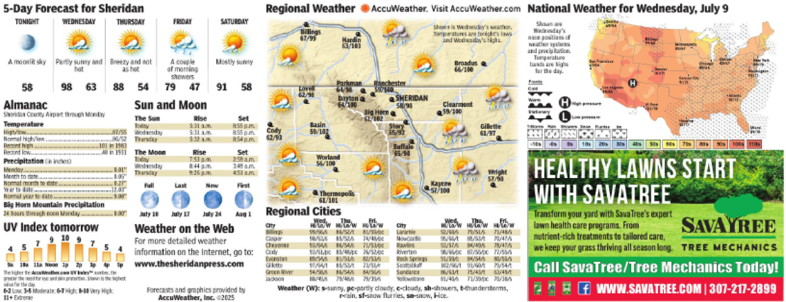
5-Day Forecast for Sheridan TONIGHT WEDNESDAY THURSDAY FRIDAY SATURDAY Regional Weather AccuWeather. Visit AccuWeather.com National Weather for Wednesday, July 9 Billings 67/99 Hardin 63/103 Shows is Wednesday's weather. Temperatures are tonight's laws 2nd Wednesday's highs. Broadus 66/100 Shown are Wednesday's noon positions of weather stems and precipitation Temperature bands are highs for the day. A moonlit sky Partly sunny and Breezy and not hot ashot 58 98 63 A couple of morning showers 88 54 79 47 Mostly sunny Parkman 91 58 Lovell 62/98 6038 Ranchester 50140 H 9177 Dayton Almanac Sheridan County Airport through Monday Temperature Sun and Moon 64/100 SHERIDAN 58/98 Big Hern Clearmont 59/100 H The Sun Rise Today 5:31 am. Set 8:55 pm. 61/102 High/low 87/55 Wednesday 5:31 am 8:55 pm. Normal high/low. 86/52 Thursday 5:32 am 8:54pm. Cody 62/93 Basin 55/102 Story 65/92 Stationary Gillette 61/97 Record high... 101 in 1983 Recond low 40 in 1931 The Moon Rise Set Buffalo 65/90 Precipitation (in inches) Today 7:53 pm Monday.... Wednesday 01 Thursday 8:44 pm 9:26pm 2:58am. 3:49 am 451a.m. Worland 56/100 Month to date... 05 Normal month to date. 127 Full Last New First Wear to date 12.05 Normal year to date. Thermopolis 61/101 Wright 57/98 57/100 Big Horn Mountain Precipitation 24 hours through noon Monday. 100 July 10 July 17 July 24 Aug 1 Regional Cities Wed UV Index tomorrow Weather on the Web City How How HULW City 10 7 7 For more detailed weather 585/5274/4 Now 5 Chey 53/54 84/54/5 1/5 Rawlins information on the Internet, go to: cody Salla Noon 1pppp The higher the Weather.com UV Index she greater the need for eye and skin protection. Shown is the for the day 0-2 Low 3-5 Moderate: 6-7 High: 8-10 Very High: 11+ Extreme www.thesheridanpress.com Forecasts and graphics provided by AccuWeather, Inc. ©2025 Evanston lette Green River Jackson MYSA SUSUS 8755 51/64/1 54/58 5/5/3/5 56/54/5 4/5 Riverton Rock Springs Scottsblu Sundance Yellowstone Wed, HW HW How 8/10/47/5 5575 84/40578475 86/56/DC 17/55/ 91/30 84/54/8555 102/6/11/6/1 M54 86/43/175/43/63/45/ 81/4/5 11/30/10/38 Weather (W): s-sunny, pe-partly cloudy, e-cloudy, sh-showers, t-thunderstorms, rrain, sf-snow flurries, sn-snow, ice. 10s 20s HEALTHY LAWNS START WITH SAVATREE Transform your yard with Sava Tree's expert lawn health care programs. From nutrient-rich treatments to tailored care, 100% 110s SAVAYREE we keep your grass thriving all season long. TREE MECHANICS Call SavaTree/Tree Mechanics Today! WWW.SAVATREE.COM | 307-217-2899 5 - Day Forecast for Sheridan TONIGHT WEDNESDAY THURSDAY FRIDAY SATURDAY Regional Weather AccuWeather . Visit AccuWeather.com National Weather for Wednesday , July 9 Billings 67/99 Hardin 63/103 Shows is Wednesday's weather . Temperatures are tonight's laws 2nd Wednesday's highs . Broadus 66/100 Shown are Wednesday's noon positions of weather stems and precipitation Temperature bands are highs for the day . A moonlit sky Partly sunny and Breezy and not hot ashot 58 98 63 A couple of morning showers 88 54 79 47 Mostly sunny Parkman 91 58 Lovell 62/98 6038 Ranchester 50140 H 9177 Dayton Almanac Sheridan County Airport through Monday Temperature Sun and Moon 64/100 SHERIDAN 58/98 Big Hern Clearmont 59/100 H The Sun Rise Today 5:31 am . Set 8:55 pm . 61/102 High / low 87/55 Wednesday 5:31 am 8:55 pm . Normal high / low . 86/52 Thursday 5:32 am 8:54 pm . Cody 62/93 Basin 55/102 Story 65/92 Stationary Gillette 61/97 Record high ... 101 in 1983 Recond low 40 in 1931 The Moon Rise Set Buffalo 65/90 Precipitation ( in inches ) Today 7:53 pm Monday .... Wednesday 01 Thursday 8:44 pm 9:26 pm 2:58 am . 3:49 am 451a.m. Worland 56/100 Month to date ... 05 Normal month to date . 127 Full Last New First Wear to date 12.05 Normal year to date . Thermopolis 61/101 Wright 57/98 57/100 Big Horn Mountain Precipitation 24 hours through noon Monday . 100 July 10 July 17 July 24 Aug 1 Regional Cities Wed UV Index tomorrow Weather on the Web City How How HULW City 10 7 7 For more detailed weather 585/5274/4 Now 5 Chey 53/54 84/54/5 1/5 Rawlins information on the Internet , go to : cody Salla Noon 1pppp The higher the Weather.com UV Index she greater the need for eye and skin protection . Shown is the for the day 0-2 Low 3-5 Moderate : 6-7 High : 8-10 Very High : 11+ Extreme www.thesheridanpress.com Forecasts and graphics provided by AccuWeather , Inc. © 2025 Evanston lette Green River Jackson MYSA SUSUS 8755 51/64/1 54/58 5/5/3/5 56/54/5 4/5 Riverton Rock Springs Scottsblu Sundance Yellowstone Wed , HW HW How 8/10/47/5 5575 84/40578475 86 / 56 / DC 17 / 55 / 91/30 84/54/8555 102/6/11/6/1 M54 86 / 43 / 175 / 43 / 63 / 45 / 81/4/5 11/30/10/38 Weather ( W ) : s - sunny , pe - partly cloudy , e - cloudy , sh - showers , t - thunderstorms , rrain , sf - snow flurries , sn - snow , ice . 10s 20s HEALTHY LAWNS START WITH SAVATREE Transform your yard with Sava Tree's expert lawn health care programs . From nutrient - rich treatments to tailored care , 100 % 110s SAVAYREE we keep your grass thriving all season long . TREE MECHANICS Call SavaTree / Tree Mechanics Today ! WWW.SAVATREE.COM | 307-217-2899