
Advertisement
-
Published Date
July 2, 2025This ad was originally published on this date and may contain an offer that is no longer valid. To learn more about this business and its most recent offers, click here.
Ad Text
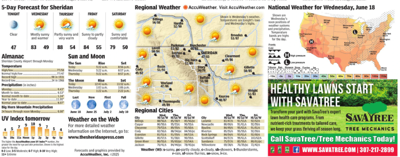
5-Day Forecast for Sheridan TONIGHT WEDNESDAY THURSDAY FRIDAY SATURDAY Clear Mostly sunny Partly sunny and Sunny to partly and warmer very warm cloudy Sunny and comfortable 47 83 49 Parkman Ranchester 88 54 84 55 79 50 Lovell 50/84 51/82 Almanac Sheridan County Airport through Monday Sun and Moon Dayton o 49.83 SHERIDAN 47/83 Regional Weather AccuWeather. Visit AccuWeather.com National Weather for Wednesday, June 18 Billings 56/88 Hardin 52/90 Shown is Wednesday's weather. Temperatures are tonight's lows and Wednesday's highs. Broadus 53/87 Shown are Wednesday's noon positions of weather systems and precipitation. Temperature bands are highs for the day. Fronts Call Warm Chicago 2 H Eass tr Temperature The Sun Today Rise Set Big Horn 51/89 Clearmont 49/86 High pressur Stationary Low pressure 5:22 a.m. 8:56 pm. High/low........ 77/50 Wednesday 5:22 a.m. 8:57 pm. Normal high/low.. 77/47 Thursday 5:22 a.m. 8:57 pm. Cody 49/82 Basin 51/91 Story 50/76 Gillette 50/85 Rain Showers Snow Record high ..98 in 1931 Record low ..34 in 1966 The Moon Rise Set Buffalo 51/80 -10s -Os 50s 60s 70s 10s 20s 30s 40s 80s 90s 100s 110s Precipitation (in inches) Today 12:43 a.m. Monday Wednesday 1:03 a.m. Thursday 1:22 a.m. 11:52 am. 1:06 pm 2:22pm. Worland 47/86 Month to date.... 0.53 Normal month to date. 1.24 Last New First Full Year to date 11.95 Normal year to date. 8.07 Thermopolis 49/89 Wright 51/83 Kaycee 48/87 7 5 Big Horn Mountain Precipitation 24 hours through noon Monday......00 UV Index tomorrow 9 10 9 Sa 10a 11a Noom 1p 2p 3p 4p 5p The higher the AccuWeather.com UV Index number, the greater the need for eye and skin protection. Shown is the highest value for the day 0-2 Low: 3-5 Moderate; 6-7 High: 8-10 Very High; 11+ Extreme Www.thesheridanpress.com Forecasts and graphics provided by AccuWeather, Inc. <2025 June 18 June 25 July 2 Weather on the Web July 10 Regional Cities For more detailed weather City Billings Casper Cheyenne information on the Internet, go to: Cody Evanston Gilette Green River Jackson Wed, Thu Fri. Hi/Lo/W Hi/Lo/W Hi/Lo/W 88/56/5 85/58/t 85/56/pc 86/50/5 95/53/c 95/55/5 79/53/s 89/59/5 95/60/s 82/56/5 88/54/pc 84/50/pc 81/51/S 91/59/5 84/53/s 85/57/5 91/58/C 90/59/5 86/55/5 95/60/pc 93/54/s 76/41/5 City Laramie Newcastle Rawlins Riverton Rock Springs Scottsbluff Sundance 84/44/pc 78/45/pc Yellowstone Wed. Thu, Fri Hi/Lo/W Hi/Low Hi/Lo/W 83/47/5 91/53/6 92/52/5 80/60/5 91/61/ 92/59/5 84/45/5 95/63/5 91/61/5 85/55/ 95/59/ 92/59/5 84/54/5 93/61/ 92/60/5 84/57/5 99/61/5 103/62/5 75/57/5 82/59/5 80/61/pc 69/35/5 76/39/C 72/42/5 Weather (W): s-sunny, pe-partly cloudy, c-cloudy, sh-showers, t-thunderstorms, r-rain, sf-snow flurries, sn-snow, i-ice. HEALTHY LAWNS START WITH SAVATREE Transform your yard with SavaTree's expert lawn health care programs. From nutrient-rich treatments to tailored care, SAVAYREE we keep your grass thriving all season long. TREE MECHANICS Call SavaTree/Tree Mechanics Today! f WWW.SAVATREE.COM | 307-217-2899 5 - Day Forecast for Sheridan TONIGHT WEDNESDAY THURSDAY FRIDAY SATURDAY Clear Mostly sunny Partly sunny and Sunny to partly and warmer very warm cloudy Sunny and comfortable 47 83 49 Parkman Ranchester 88 54 84 55 79 50 Lovell 50/84 51/82 Almanac Sheridan County Airport through Monday Sun and Moon Dayton o 49.83 SHERIDAN 47/83 Regional Weather AccuWeather . Visit AccuWeather.com National Weather for Wednesday , June 18 Billings 56/88 Hardin 52/90 Shown is Wednesday's weather . Temperatures are tonight's lows and Wednesday's highs . Broadus 53/87 Shown are Wednesday's noon positions of weather systems and precipitation . Temperature bands are highs for the day . Fronts Call Warm Chicago 2 H Eass tr Temperature The Sun Today Rise Set Big Horn 51/89 Clearmont 49/86 High pressur Stationary Low pressure 5:22 a.m. 8:56 pm . High / low ........ 77/50 Wednesday 5:22 a.m. 8:57 pm . Normal high / low .. 77/47 Thursday 5:22 a.m. 8:57 pm . Cody 49/82 Basin 51/91 Story 50/76 Gillette 50/85 Rain Showers Snow Record high ..98 in 1931 Record low ..34 in 1966 The Moon Rise Set Buffalo 51/80 -10s -Os 50s 60s 70s 10s 20s 30s 40s 80s 90s 100s 110s Precipitation ( in inches ) Today 12:43 a.m. Monday Wednesday 1:03 a.m. Thursday 1:22 a.m. 11:52 am . 1:06 pm 2:22 pm . Worland 47/86 Month to date .... 0.53 Normal month to date . 1.24 Last New First Full Year to date 11.95 Normal year to date . 8.07 Thermopolis 49/89 Wright 51/83 Kaycee 48/87 7 5 Big Horn Mountain Precipitation 24 hours through noon Monday ...... 00 UV Index tomorrow 9 10 9 Sa 10a 11a Noom 1p 2p 3p 4p 5p The higher the AccuWeather.com UV Index number , the greater the need for eye and skin protection . Shown is the highest value for the day 0-2 Low : 3-5 Moderate ; 6-7 High : 8-10 Very High ; 11+ Extreme Www.thesheridanpress.com Forecasts and graphics provided by AccuWeather , Inc. < 2025 June 18 June 25 July 2 Weather on the Web July 10 Regional Cities For more detailed weather City Billings Casper Cheyenne information on the Internet , go to : Cody Evanston Gilette Green River Jackson Wed , Thu Fri. Hi / Lo / W Hi / Lo / W Hi / Lo / W 88/56/5 85 / 58 / t 85 / 56 / pc 86/50/5 95 / 53 / c 95/55/5 79 / 53 / s 89/59/5 95 / 60 / s 82/56/5 88 / 54 / pc 84 / 50 / pc 81 / 51 / S 91/59/5 84 / 53 / s 85/57/5 91 / 58 / C 90/59/5 86/55/5 95 / 60 / pc 93 / 54 / s 76/41/5 City Laramie Newcastle Rawlins Riverton Rock Springs Scottsbluff Sundance 84 / 44 / pc 78 / 45 / pc Yellowstone Wed. Thu , Fri Hi / Lo / W Hi / Low Hi / Lo / W 83/47/5 91/53/6 92/52/5 80/60/5 91 / 61 / 92/59/5 84/45/5 95/63/5 91/61/5 85 / 55 / 95 / 59 / 92/59/5 84/54/5 93 / 61 / 92/60/5 84/57/5 99/61/5 103/62/5 75/57/5 82/59/5 80 / 61 / pc 69/35/5 76 / 39 / C 72/42/5 Weather ( W ) : s - sunny , pe - partly cloudy , c - cloudy , sh - showers , t - thunderstorms , r - rain , sf - snow flurries , sn - snow , i - ice . HEALTHY LAWNS START WITH SAVATREE Transform your yard with SavaTree's expert lawn health care programs . From nutrient - rich treatments to tailored care , SAVAYREE we keep your grass thriving all season long . TREE MECHANICS Call SavaTree / Tree Mechanics Today ! f WWW.SAVATREE.COM | 307-217-2899