
Advertisement
-
Published Date
April 8, 2025This ad was originally published on this date and may contain an offer that is no longer valid. To learn more about this business and its most recent offers, click here.
Ad Text
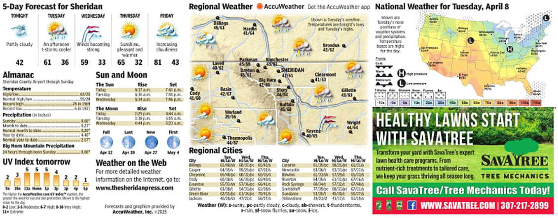
5-Day Forecast for Sheridan TONIGHT TUESDAY WEDNESDAY THURSDAY FRIDAY Regional Weather AccuWeather. Get the AccuWeather app National Weather for Tuesday, April 8 Balings 45/61 Hardin 41/64 Shown is Tuesday's weather. Temperatures are tonight's lows and Tuesday's highs Broadus 43/62 Shown are Tuesday's noon positions of weather systems and precipitation. Temperature bands are highs for the day. Cry Partly cloudy An afternoon t-storm: cooler Winds becoming strong Sunshine, pleasant and Increasing cloudiness warmer 42 Almanac 61 36 59 33 65 32 81 43 Sheridan County Airport through Sunday Sun and Moon The Sun Parkman Ranchester Lovell 45/59 43/61 40/62 Daytona 45/61 SHERIDAN 42/61 Clearmont Big Horn ( 42/66 41/63 Story 44/54 Buffalo 45/60 Worland 39/66 Rise Set Temperature Today 6:37 am 7:43 pm Basin HigVow 62/25 Tuesday 6:36 am 7:44 pm. Cody 42/67 Normal high/low.. 55/28 Wednesday 6:34 am 7:46pm 41/60 Recard high. 78 in 1969 Recard low 6 in 1911 The Moon Rise Set Precipitation (in inches) Today 2:29 pm 4:44 am Tuesday 1:38 pm. 5:05 am. Sunday 0.00 Month to date... 0.27 Wednesday 6:44 pm 5:23am Normal month to date. 0.29 Full Last New First Year to date 4.40 Normal year to date. 2.57 Big Horn Mountain Precipitation 24 hours through noon Sunday... 0.00 Apr 12 Apr 20 Apr 27 City Bings 5 5 5 4 UV Index tomorrow Weather on the Web Thermopolis 44/67 May 4 Regional Cities For more detailed weather information on the Internet, go to: Sa 10a 11a Noon 1p 2p p 4 Sp www.thesheridanpress.com The higher the AccuWeather.com UV Index" sunber, the greator the need for eye and skin protection. Shove is the highest vale for the day 6-2 Low: 3-5 Moderate: 6-7 High: 8-10 Very High 11+ Extreme Forecasts and graphics provided by AccuWeather, Inc. 2025 Casper Cheyenne Cody Evanston Gillette Green River Jackson Tue, Wed H/W Hi/Lo/W HOW 61/40/h 60/37/pe 65/43/5 64/35/5 59/29/pc 67/12/5 66/40/pc 60/32/pc 65/35/5 60/38/5 56/31/pe 65/40/5 55/33/h 57/36/pc 66/41/c 63/38/t 54/33/pc 61/385 62/15/pc 61/34/pc 70/41/5 45/28/h 47/22/c 56/27/5 City Laramie Newcastle Rawlins Riverton Rock Springs Scottsbluff Sundance Yellowstone Gilette 43/63 Wright 44/64 Kaycee 40/65 Tue Wed. HLOW HULW H/LOW 61/35/pe 58/25/pe 61/11/5 63/16/153/33/pt 57/37/5 61/33/h 57/29/65/13/5 64/35/5 61/31/9 67/16/5 60/34/ 57/32/ 67/40/5 77/35/pc 68/33/9 1 53/35/45/30/ 33/23 41/17/ 50/37/5 51/15/5 Weather (W): s-sunny, pe-partly cloudy, e-cloudy, sh-showers, t-thunderstorms, rrain, sf-snow flurries, sa-snow, l-ice. Coll High pressure 10 HEALTHY LAWNS START WITH SAVATREE Transform your yard with Sava Tree's expert lawn health care programs. From nutrient-rich treatments to tailored care, 100 110 SAVAYREE we keep your grass thriving all season long. TREE MECHANICS Call SavaTree/Tree Mechanics Today! f WWW.SAVATREE.COM | 307-217-2899 5 - Day Forecast for Sheridan TONIGHT TUESDAY WEDNESDAY THURSDAY FRIDAY Regional Weather AccuWeather . Get the AccuWeather app National Weather for Tuesday , April 8 Balings 45/61 Hardin 41/64 Shown is Tuesday's weather . Temperatures are tonight's lows and Tuesday's highs Broadus 43/62 Shown are Tuesday's noon positions of weather systems and precipitation . Temperature bands are highs for the day . Cry Partly cloudy An afternoon t - storm : cooler Winds becoming strong Sunshine , pleasant and Increasing cloudiness warmer 42 Almanac 61 36 59 33 65 32 81 43 Sheridan County Airport through Sunday Sun and Moon The Sun Parkman Ranchester Lovell 45/59 43/61 40/62 Daytona 45/61 SHERIDAN 42/61 Clearmont Big Horn ( 42/66 41/63 Story 44/54 Buffalo 45/60 Worland 39/66 Rise Set Temperature Today 6:37 am 7:43 pm Basin HigVow 62/25 Tuesday 6:36 am 7:44 pm . Cody 42/67 Normal high / low .. 55/28 Wednesday 6:34 am 7:46 pm 41/60 Recard high . 78 in 1969 Recard low 6 in 1911 The Moon Rise Set Precipitation ( in inches ) Today 2:29 pm 4:44 am Tuesday 1:38 pm . 5:05 am . Sunday 0.00 Month to date ... 0.27 Wednesday 6:44 pm 5:23 am Normal month to date . 0.29 Full Last New First Year to date 4.40 Normal year to date . 2.57 Big Horn Mountain Precipitation 24 hours through noon Sunday ... 0.00 Apr 12 Apr 20 Apr 27 City Bings 5 5 5 4 UV Index tomorrow Weather on the Web Thermopolis 44/67 May 4 Regional Cities For more detailed weather information on the Internet , go to : Sa 10a 11a Noon 1p 2p p 4 Sp www.thesheridanpress.com The higher the AccuWeather.com UV Index " sunber , the greator the need for eye and skin protection . Shove is the highest vale for the day 6-2 Low : 3-5 Moderate : 6-7 High : 8-10 Very High 11+ Extreme Forecasts and graphics provided by AccuWeather , Inc. 2025 Casper Cheyenne Cody Evanston Gillette Green River Jackson Tue , Wed H / W Hi / Lo / W HOW 61 / 40 / h 60 / 37 / pe 65/43/5 64/35/5 59 / 29 / pc 67/12/5 66 / 40 / pc 60 / 32 / pc 65/35/5 60/38/5 56 / 31 / pe 65/40/5 55 / 33 / h 57 / 36 / pc 66 / 41 / c 63 / 38 / t 54 / 33 / pc 61/385 62 / 15 / pc 61 / 34 / pc 70/41/5 45 / 28 / h 47 / 22 / c 56/27/5 City Laramie Newcastle Rawlins Riverton Rock Springs Scottsbluff Sundance Yellowstone Gilette 43/63 Wright 44/64 Kaycee 40/65 Tue Wed. HLOW HULW H / LOW 61 / 35 / pe 58 / 25 / pe 61/11/5 63 / 16 / 153 / 33 / pt 57/37/5 61 / 33 / h 57/29/65/13/5 64/35/5 61/31/9 67/16/5 60 / 34 / 57 / 32 / 67/40/5 77 / 35 / pc 68/33/9 1 53 / 35 / 45 / 30 / 33/23 41 / 17 / 50/37/5 51/15/5 Weather ( W ) : s - sunny , pe - partly cloudy , e - cloudy , sh - showers , t - thunderstorms , rrain , sf - snow flurries , sa - snow , l - ice . Coll High pressure 10 HEALTHY LAWNS START WITH SAVATREE Transform your yard with Sava Tree's expert lawn health care programs . From nutrient - rich treatments to tailored care , 100 110 SAVAYREE we keep your grass thriving all season long . TREE MECHANICS Call SavaTree / Tree Mechanics Today ! f WWW.SAVATREE.COM | 307-217-2899