
Advertisement
-
Published Date
April 30, 2025This ad was originally published on this date and may contain an offer that is no longer valid. To learn more about this business and its most recent offers, click here.
Ad Text
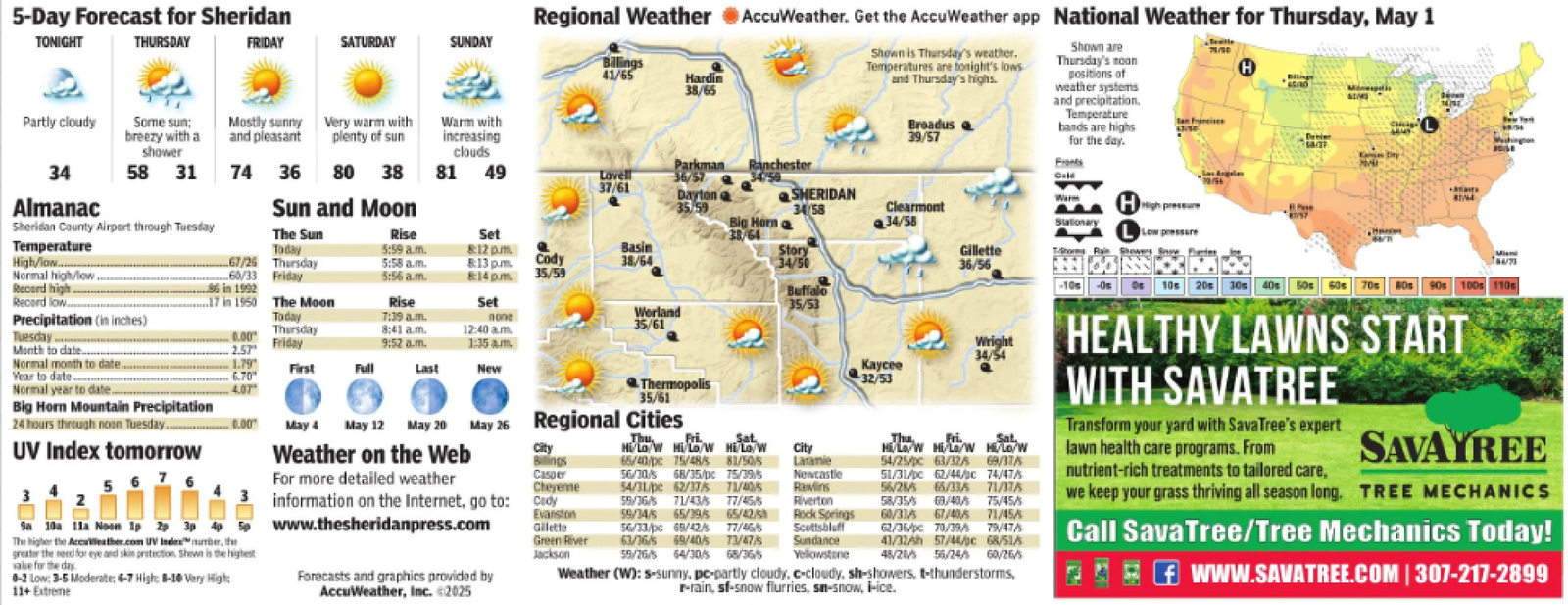
5-Day Forecast for Sheridan TONIGHT THURSDAY FRIDAY SATURDAY SUNDAY Almanac Sheridan County Airport through Tuesday Temperature High/low....... Normal high/low. Today 67/26 Thursday 60/33 Friday Regional Weather AccuWeather. Get the AccuWeather app National Weather for Thursday, May 1 Shown is Thursday's weather. Temperatures are tonight's lows and Thursday's highs. Broadus 39/57 Billings 41/65 Hardin 38/65 Partly cloudy Some sun; breezy with a Mostly sunny and pleasant Very warm with plenty of sun Warm with increasing shower clouds 34 58 31 74 36 80 38 Parkman Ranchester 81 49 Lovell 36/57 37/61 Dayton e Sun and Moon 35/59 SHERIDAN 34/58 The Sun Rise Set Big Horn a 38/64 Clearmont 34/58 5:59 a.m. 8:12 pm Basin Story 5:58 a.m. 8:13 p.m. Cody 38/64 34/50 Gillette 36/56 5:56 am. &14 p.m. 35/59 ..86 in 1992 17 in 1950 The Moon Rise Set Buffalo 35/53 Precipitation (in inches) Today 7:39 a.m. Tuesday...... -0.00 Month to date. Thursday Friday Worland 35/61 8:41 a.m. 9:52 a.m. 12:40 am 1:35am. Normal month to date.. 1.79 First Full Last New Year to date 6.70 Normal year to date. 4.07 Big Horn Mountain Precipitation 24 hours through noon Tuesday.... -0.00° Record high.. Record low.... UV Index tomorrow 5676 2.57 9a 10a 11a Noon 1p 2p 3p 4p 5 The higher the AccuWeather.com UV Index number, the greater the need for eye and skin protection. Shown is the highest value for the day 0-2 Low: 3-5 Moderate; 6-7 High: 8-10 Very High: 11+ Extreme none Thermopolis 35/61 May 26 Regional Cities May 4 May 12 May 20 May 26 Weather on the Web For more detailed weather information on the Internet, go to: www.thesheridanpress.com Forecasts and graphics provided by AccuWeather, Inc. 2025 City Billings Casper Cheyenne Evanston Gillette Green River Jackson Thu Fri Sat Hi/Lo/W Hi/Lo/W Hi/Lo/W 65/40/pc 15/48/5 81/50/5 56/30/s 68/35/pc 15/39/5 54/31/pe 62/37/5 71/40/5 59/36/5 71/43/5 77/45/5 59/34/5 65/39/5 65/42/sh 56/33/pc 65/42/s 17/46/s 63/36/s 69/40/s 73/47/s 59/26/5 64/30/5 68/36/5 City Laramie Newcastle Rawlins Riverton Rock Springs Scottsbluff Sundance Yellowstone Wright 34/54 32/53 Thu Fri Sat, Hi/Lo/W Hi/Lo/W Hi/Lo/W 54/25/pc 63/32/5 69/37/5 51/31/pc 62/44/pc 74/47/5 56/28/ 65/33/5 71/37/5 58/35/ 69/40/5 75/45/5 60/33/5 67/40/5 71/45/5 62/36/pc 70/39/ 79/47/5 43/32/h 57/44/pc 68/51/s 48/20/5 56/24/5 60/26/5 Weather (W): s-sunny, pc-partly cloudy, c-cloudy, sh-showers, t-thunderstorms, r-rain, sf-snow flurries, sm-snow, i-ice. Shown are Thursday's moon positions of weather systems and precipitation. Temperature bands are highs for the day. Frants Cold Stationary HHigh pressure Low pressure Rain Showe Los Angeles H Detien -10s - Os 10s 20s 30s 40s 50s 60s 70s 80s 90s 100s 110s HEALTHY LAWNS START WITH SAVATREE Transform your yard with Sava Tree's expert lawn health care programs. From nutrient-rich treatments to tailored care, SAVAYREE we keep your grass thriving all season long. TREE MECHANICS Call SavaTree/Tree Mechanics Today! WWW.SAVATREE.COM | 307-217-2899 5 - Day Forecast for Sheridan TONIGHT THURSDAY FRIDAY SATURDAY SUNDAY Almanac Sheridan County Airport through Tuesday Temperature High / low ....... Normal high / low . Today 67/26 Thursday 60/33 Friday Regional Weather AccuWeather . Get the AccuWeather app National Weather for Thursday , May 1 Shown is Thursday's weather . Temperatures are tonight's lows and Thursday's highs . Broadus 39/57 Billings 41/65 Hardin 38/65 Partly cloudy Some sun ; breezy with a Mostly sunny and pleasant Very warm with plenty of sun Warm with increasing shower clouds 34 58 31 74 36 80 38 Parkman Ranchester 81 49 Lovell 36/57 37/61 Dayton e Sun and Moon 35/59 SHERIDAN 34/58 The Sun Rise Set Big Horn a 38/64 Clearmont 34/58 5:59 a.m. 8:12 pm Basin Story 5:58 a.m. 8:13 p.m. Cody 38/64 34/50 Gillette 36/56 5:56 am . & 14 p.m. 35/59 ..86 in 1992 17 in 1950 The Moon Rise Set Buffalo 35/53 Precipitation ( in inches ) Today 7:39 a.m. Tuesday ...... -0.00 Month to date . Thursday Friday Worland 35/61 8:41 a.m. 9:52 a.m. 12:40 am 1:35 am . Normal month to date .. 1.79 First Full Last New Year to date 6.70 Normal year to date . 4.07 Big Horn Mountain Precipitation 24 hours through noon Tuesday . . .. -0.00 ° Record high .. Record low .... UV Index tomorrow 5676 2.57 9a 10a 11a Noon 1p 2p 3p 4p 5 The higher the AccuWeather.com UV Index number , the greater the need for eye and skin protection . Shown is the highest value for the day 0-2 Low : 3-5 Moderate ; 6-7 High : 8-10 Very High : 11+ Extreme none Thermopolis 35/61 May 26 Regional Cities May 4 May 12 May 20 May 26 Weather on the Web For more detailed weather information on the Internet , go to : www.thesheridanpress.com Forecasts and graphics provided by AccuWeather , Inc. 2025 City Billings Casper Cheyenne Evanston Gillette Green River Jackson Thu Fri Sat Hi / Lo / W Hi / Lo / W Hi / Lo / W 65 / 40 / pc 15/48/5 81/50/5 56 / 30 / s 68 / 35 / pc 15/39/5 54 / 31 / pe 62/37/5 71/40/5 59/36/5 71/43/5 77/45/5 59/34/5 65/39/5 65 / 42 / sh 56 / 33 / pc 65 / 42 / s 17 / 46 / s 63 / 36 / s 69 / 40 / s 73 / 47 / s 59/26/5 64/30/5 68/36/5 City Laramie Newcastle Rawlins Riverton Rock Springs Scottsbluff Sundance Yellowstone Wright 34/54 32/53 Thu Fri Sat , Hi / Lo / W Hi / Lo / W Hi / Lo / W 54 / 25 / pc 63/32/5 69/37/5 51 / 31 / pc 62 / 44 / pc 74/47/5 56 / 28 / 65/33/5 71/37/5 58 / 35 / 69/40/5 75/45/5 60/33/5 67/40/5 71/45/5 62 / 36 / pc 70 / 39 / 79/47/5 43 / 32 / h 57 / 44 / pc 68 / 51 / s 48/20/5 56/24/5 60/26/5 Weather ( W ) : s - sunny , pc - partly cloudy , c - cloudy , sh - showers , t - thunderstorms , r - rain , sf - snow flurries , sm - snow , i - ice . Shown are Thursday's moon positions of weather systems and precipitation . Temperature bands are highs for the day . Frants Cold Stationary HHigh pressure Low pressure Rain Showe Los Angeles H Detien -10s - Os 10s 20s 30s 40s 50s 60s 70s 80s 90s 100s 110s HEALTHY LAWNS START WITH SAVATREE Transform your yard with Sava Tree's expert lawn health care programs . From nutrient - rich treatments to tailored care , SAVAYREE we keep your grass thriving all season long . TREE MECHANICS Call SavaTree / Tree Mechanics Today ! WWW.SAVATREE.COM | 307-217-2899